A recent informative article on ESA’s Global Development Assistance Programme website, co-written by our director Roberto Rudari, reviews the monitoring and mapping of flooded areas during the Pakistan floods, highlighting the importance of EO tools also for impact assessment and post-event recovery strategies
How can Earth observation services, such as satellites, provide help during emergencies? Recently, Roberto Rudari, director of Multi-Risk Assessment and Data-Informed Policies programme of CIMA Research Foundation, co-authored an informative article on this very topic. Published on the website of ESA’s Global Development Assistance Programme, the text traces the satellite monitoring activities during disasters to which CIMA Research Foundation contributed during the severe floods in Pakistan, at the request of theAsian Development Bank (ADB), together with Luxembourg Institute of Science and Technology (LIST). Together with the latter, CIMA Research Foundation is part of the GDA consortium, which aims to demonstrate and exploit the use of Earth observation in all phases of the disaster risk management cycle.
Preparation and monitoring, but also evaluations of the impacts caused by the event that can help establish strategies and needs once the event is over: these are the main elements with which Earth Observation (EO) services have proven to be particularly important.
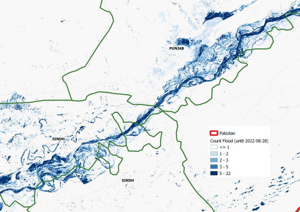
The article, also signed by Indra’s Miguel Angel Belenguer-Plomer and ESA’s Charlotte Fafet, begins by retracing what happened in Pakistan over the summer leading up to the declaration of a state of emergency at the end of August. The impacts were terrible, with 10% of the country flooded and over a thousand victims: unfortunately, the authors remind us, this type of event is influenced by climate change, which will increase its frequency and intensity.
This is why it is so important to be able to provide ever better responses, guaranteeing timely and effective risk management. It is with this in mind that satellite services have proved invaluable: they have made it possible to map the entire country through the images acquired by the Sentinel-1 and Sentinel-2 satellites, processed using an advanced algorithm. This, the authors explain, made it possible not only to establish the extent of the floods and monitor their progression, but also to estimate the depth of the water – a crucial piece of information for assessing the possible impact on buildings and infrastructure.
“Another important aspect of the work in Pakistan is the Post-Disaster Needs Assessment,” explains Roberto Rudari. Post-Disaster Needs Assessments (PDNAs) aim to assess damage in different sectors, losses and recovery needs, providing an impact estimate that supports recovery.
“For this type of activity, it was possible to use the WASDI platform, developed by Fadeout in collaboration with the CIMA Research Foundation: the platform allows access to satellite data from Sentinel and commercial data providers, visualising the images and performing necessary algorithms in a common online workspace,” Rudari says. This information could then be used to identify the worst affected areas and plan efforts, investments and recovery strategies accordingly.
The work in Pakistan is also part of ESA’s eDrift project, led by CIMA Research Foundation and aimed at developing remote sensing products that enable organisations such as insurance companies and government agencies to assess the effects of disasters and fund recovery efforts. “Globally, EO services are proving increasingly useful in risk management – and, as this latest event shows, in post-event activities as well,” Rudari concludes.