In a recent paper, which gained the front cover of an issue ofInternational Journal of Wildland Fire researchers from CIMA Research Foundation’s Wildfire Risk Management Department present a fire hazard map for the Mediterranean. The map was obtained by processing a vast amount of data regarding bioclimatic, topographic and anthropic land features, through machine learning techniques.
Influenced by climate change and changes in land use, wildfires are becoming, at least in some regions of the planet, larger, more frequent, and more intense. Thus, even though we observe a decrease in burned areas in Europe over the years, thanks to an increase in awareness, timely interventions and forecasting, the risk of forest fires is increasing overall.
As a result, the need to address the risk with management and prevention activities that match the risk itself is also increasing. How? An important starting point is to understand which areas are most vulnerable. This involves, in other words, making hazard maps, where “hazard” refers to that component of risk that describes the probability of a phenomenon with a given level of intensity occurring. Ideally, this information is then cross-referenced with information regarding the presence of buildings, activities and infrastructure that could be damaged by fire, to depict the distribution of wildfire risk. This would allow to perform an informed resource allocation to strengthen prevention measures and monitoring.
This is what our researchers from the Wildfire Risk Management and Forest Conservation Department have done, in collaboration with colleagues from the CNR Institute of Geosciences and Georisources and the University of Lausanne. Their paper, which earned the cover of the International Journal of Wildland Fire, describes fire hazard mapping for a large geographic area based on machine learning technologies.
Wildfires in the Mediterranean
The Mediterranean basin is one of the areas where the risk of wildfires is found to have increased over the years, the accomplices being both climate change, which alters rainfall, and the abandonment of areas formerly used for pastoralism and agriculture, which has led to an increase in the vegetated area and, therefore, also an increase in combustible material.
If one looks at the fires that have occurred in this area over the very last few years (think of the 2021 fires in Italy, Greece, Turkey and Algeria-in the latter nation causing the deaths of 90 people), the need to adopt an increasingly preventive approach to the management of these phenomena becomes evident. An approach, then, focused not only on fire suppression but also on early warning, based on accurate forecasting and risk mitigation strategies. A goal that is far from trivial, especially considering that we still know relatively little about those defined as Extreme Wildfire Events, i.e., fires that are particularly difficult to control and have major impacts on the territory. These are complex events, which require first of all a comprehensive knowledge of the general fire regime in a given area to enable effective management, which is also based on land-use planning.
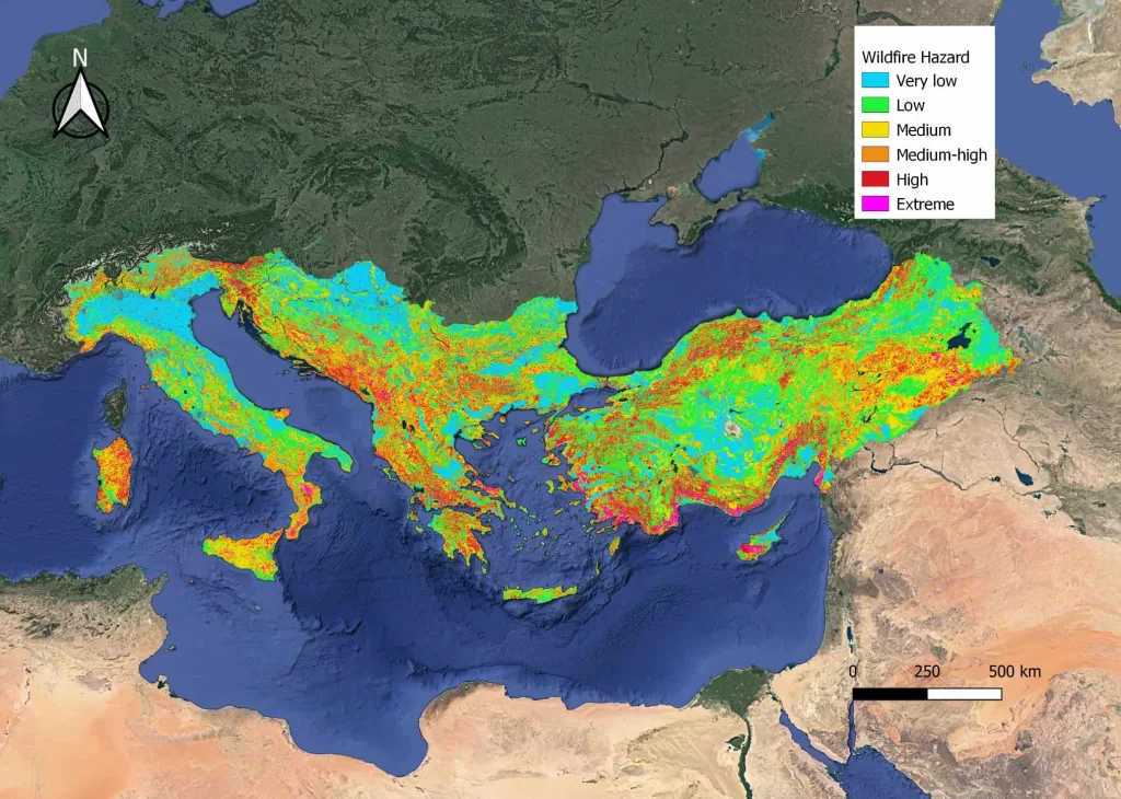
The hazard maps created by our researchers, the first at a supranational scale for the Eastern Mediterranean area, have been realized with this view. “Our mapping covers Italy, Slovenia, Croatia, the Western Balkans, Greece, Cyprus, Bulgaria and Turkey: this analysis encompasses all the regions where we are working as part of the IPA Floods&Fires project, dedicated to strengthening flood and forest fire risk management and under which it was possible to start testing our algorithms. “Overall, we are talking about a very large area and, above all, characterized by a variety of different biogeographic regions, that is, with characteristics capable of influencing fires that are very different from each other,” explains Andrea Trucchia, CIMA Research Foundation’s researcher and first author of the study.
So many regions, so much information
In assessing the likelihood of a fire occurring and trying to predict how it might behave, in fact, the climatic and geographic characteristics of the area are among the most important elements. A hot, dry climate, for example, is a greater risk factor than a humid climate; the presence of slopes, as in a mountainous terrain , can influence wildfire speed; the type of vegetation can make wildfires it more or less easy to ignite and spread. If you also want to consider the impact the fire may have on a given area, still more information is needed: how many people live in that area? Are houses, roads or other infrastructure present?
Fortunately, we have a lot of data at our disposal from international open-access databases. Gathering and cross-referencing them to create the hazard map was exactly what we did in this study: we used the information available on different systems to figure out as a first step which areas have the most fires. This first step required an analysis of data collected over the past 20 years on burned areas from the European Forest Fire Information System (EFFIS),” Dr Trucchia explains. “Then, we looked at areas that not only burn the most but also have high-density fuel, which could end up in intense fire events with also high level of risk due to the presence of infrastructure and people. This allowed us to cross-reference the presence of fires with the characteristics of the area.”
For example, the study’s authors and authors relied on databases provided by Copernicus Land Monitoring Service and CORINE to assess land cover; these and other services also allowed them to derive information on the area’s anthropogenic characteristics, such as its distance from urban centers, and its topography and climate. This is a vast amount of data to cross-reference, especially as some influence each other. For example, some databases provide information for only aggregated tree species. However, knowing the climate of the area makes it possible to hypothesize what type of forest is present and what species might develop in the area. This is where machine learning comes in, which CIMA Research Foundation had already employed to create hazard maps for Liguria.
Machine learning for forest fires
“Machine learning is an artificial intelligence technique that ‘learns’ to cross-reference and interpret data to provide predictions: it is used in many different fields, including forest fire risk prediction, but still relatively untapped for hazard mapping. In our case, it was a matter of instructing the operating system to recognize situations that increase fire risk, such as the presence of a pine forest in a dry climate, by combining the data you provide it with,” Dr Trucchia says. “In this process of ‘learning’ the algorithms, we realized that one of the most important factors to take into account, when you work at a scale this large, are the climates and microclimates of different areas, and it is important to be able to teach the system how to exploit them.”
The result is a static map, i.e., one that does not take into account, for example, daily or hourly weather variables such as wind and rain, but one that provides almost at a glance and at high resolution some of the most important information to consider for fire risk management-including mitigation strategies. For example, the map highlights the role of vegetation continuity in influencing risk: if an area has continuous vegetation cover, fire has an easier time spreading. But at the same time, one plant is not as good as another, and the presence of native forests can help limit fire spread.
“In general, an advantage of this approach is that it is very modular and flexible: by cross-referencing new layers with the different data you want to take into account, you can have a clear and immediate result,” Dr Trucchia concludes. “The path that led us to develop it started first at the regional level, with the maps for Liguria, and then gradually expanded to the national and, today, supranational level. Now we want to move forward with this work by refining the system more and more, for example by providing it with more accurate local data and also trying to take into account the seasonality of events; in addition, we are working to implement ad hoc spatial validation procedures.”
Cover image from Wildfire hazard mapping in the eastern Mediterranean landscape (Trucchia A. et al, International Journal of Wildland Fire, 2023; doi:10.1071/WF22138. License CC BY-NC-ND)