We have a chat with Paolo Fiorucci, head of the Wildfires and Forest Biodiversity Conservation Department of CIMA Research Foundation, to explain the trend of fires at the global, European and national level over the years, their relationship with climate change, risk factors and prevention and management strategies
Over the course of July, there have been (and are) several reports of fires that are affecting different areas of Europe: Spain, Portugal and France in the first place. There is no shortage of fires in various regions of Italy, from Friuli to Tuscany to the major islands and central southern regions.
Although fires are nothing new, especially this season, the relationship with the heat wave and drought that is affecting several European regions is often highlighted for those this summer. In turn, these phenomena may be linked to climate change: according to the IPCC, droughts and heat waves will increase in frequency in several regions of the world.
But what has been the trend for forest fires in recent years, in Europe and around the world? What other factors influence the risk? And, most importantly, what tools do we have to mitigate it? We talk about this with Paolo Fioruccihead of the Wildfires and Forest Biodiversity Conservation Department of CIMA Research Foundation.
Can we really say that fires have been increasing over the years?
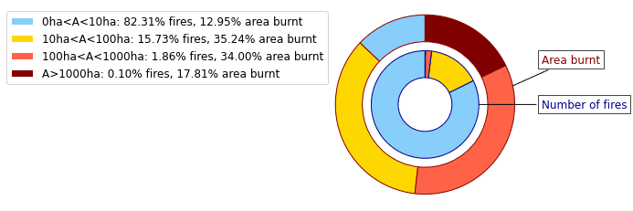
This is a statement that is often heard. However, going to look at the data collected in the scientific literature, what emerges is that we cannot generalize: in some areas we can actually observe an increase in fires, while in others these have decreased. And another thing must also be said: these global-scale analyses are only possible because of the availability of time series of satellite data, which may be subject to uncertainty. In particular, they do not allow us to distinguish between actually destructive events and the normal use of fire in agricultural practices. Practices that in some areas of the planet remain among the main causes of fire, if fire is used in conditions that do not allow its control. The lack of a harmonized system for capturing information on events also means that it is not possible to monitor the actual increase in impacts of forest fires. In other words, fires are numerous, but only a very small proportion are responsible for the overall damage.
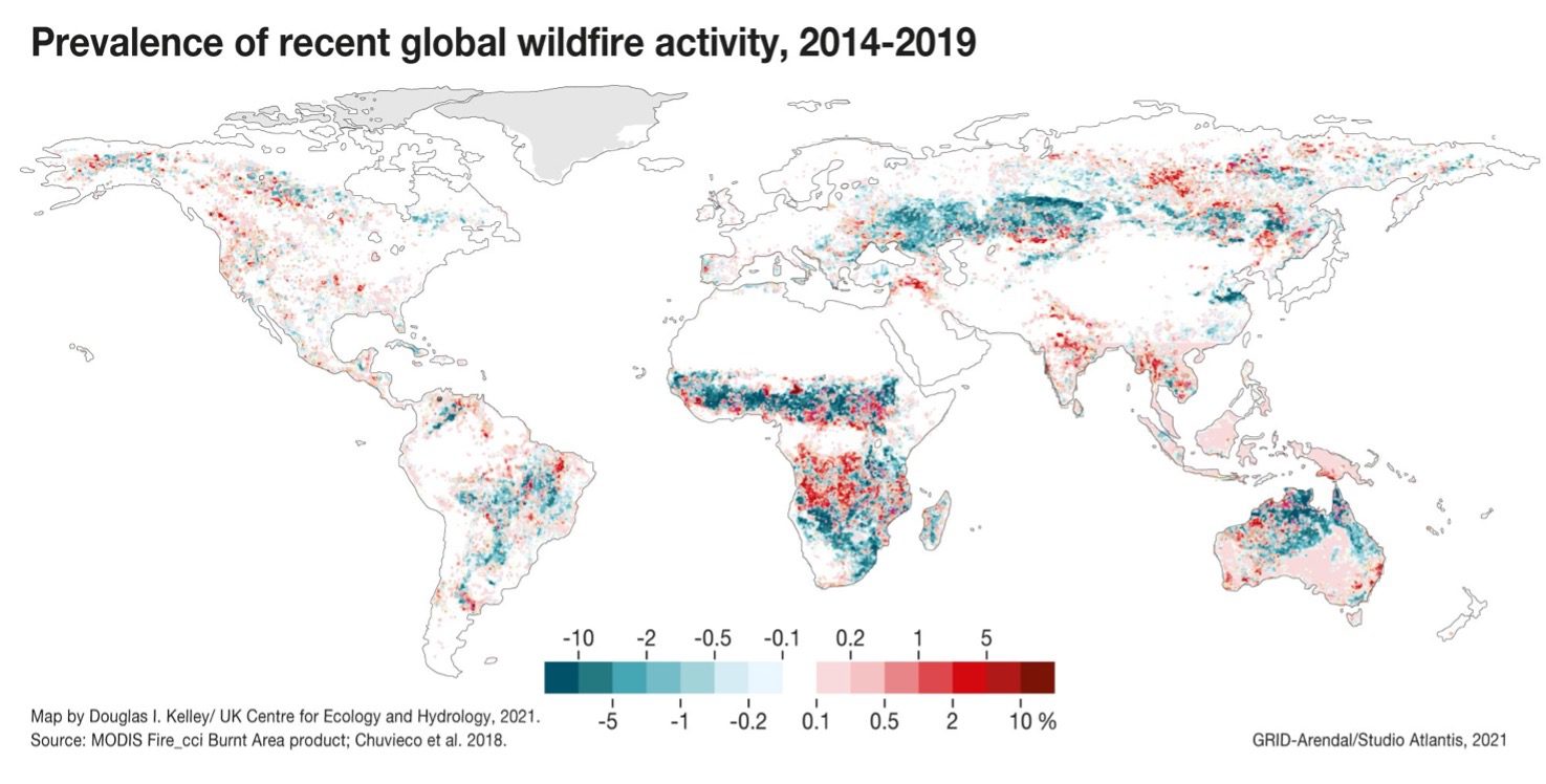
What does this difference in different regions of the world indicate?
In fact, we can say that it indicates how complex it is to assess wildfires globally, and how necessary it is instead to take into account different aspects of these phenomena and the context in which they occur. For example, California is prone to frequent fires in the summer, the number of which has remained essentially unchanged between 2011 and 2020; what has increased significantly, however, is the area burned in the course of these fires, and we cannot help but notice that the largest fires, or those that have done the most damage (such as the one in 2018 called the Camp Fire), are all from the very last few years. From analysis of the international scientific literature, we also know that fires due to human causes have been increasing in this area, while those due to natural causes, such as lightning phenomena, have remained virtually unchanged. This is not true, however, in other areas of the world where an increase in fires has been observed: this is the case in Siberia, which includes many remote areas, and where fires can therefore be related to the anticipated thawing of permafrost due to global warming. The severity of a fire is usually based on the impacts it has, but these in turn have to be evaluated in the context of socioeconomic condition, firefighting capacity, vegetation and many other aspects of the affected area.
And what is the trend for Europe?
Several studies, including some conducted by us, indicate that fire frequency has decreased overall since the 1980s, although not in all regions. In some provinces in Spain and Portugal, fires have increased, while in France, Italy and Greece, fire-covered areas show a decreasing trend. However, in almost all Mediterranean countries there is also great variability between years, corresponding to particularly hot and dry summer seasons or even just a few weeks of extreme conditions, as happened last year in southern Italy, Greece, Turkey and Algeria. In the latter case, thousands of hectares burned in just a week, and the fires claimed dozens of lives.
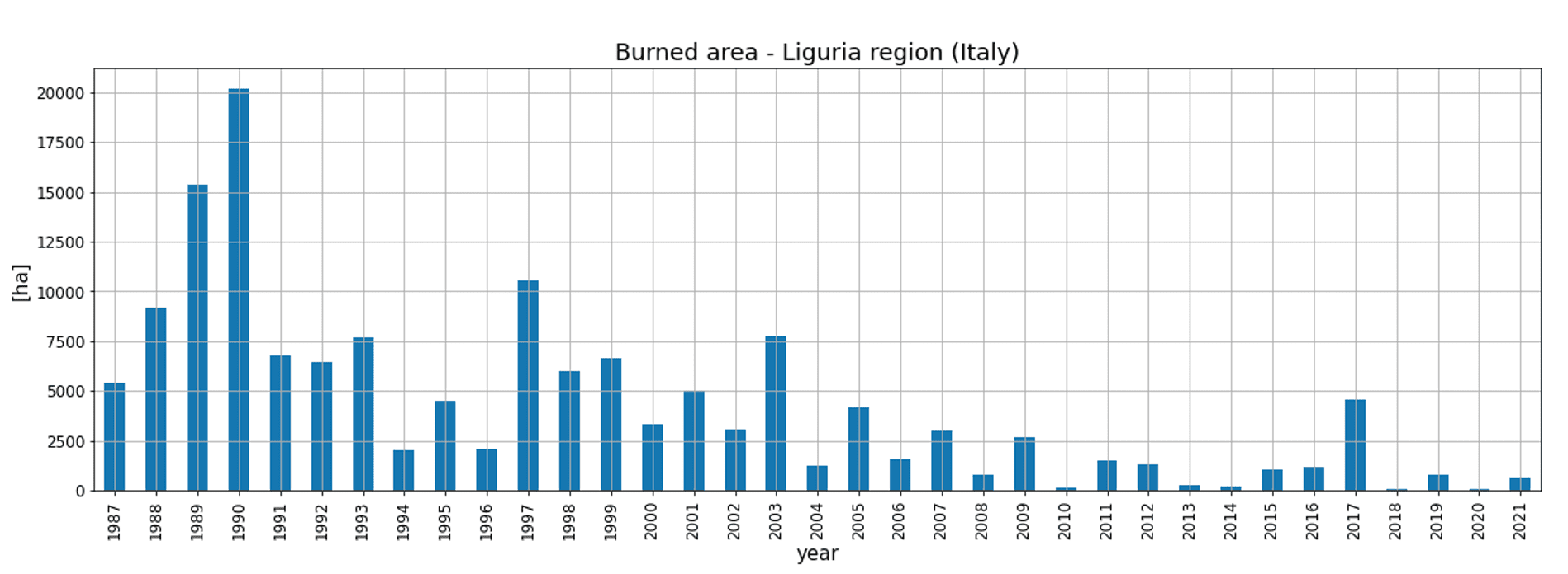
But even here, we cannot generalize at all: if we look at Liguria alone, for example, we observe a sharp decrease in both fires and burned areas over the past 30 years.
What is the reason for this general decrease in fires in Europe?
It is usually related to more efficient management, so better prevention, speed of intervention, more effective extinguishments, investment in aerial fleets, operator training, and so on. However, we cannot forget that climate change does indeed play a role in influencing fire risk and, as the latest JRC technical report also warns, heat waves and droughts can make even areas that were not previously prone to fires more vulnerable as well as increasing the frequency of extreme events and prolonging fire seasons.
All of these considerations relate primarily to the frequency and extent of fires. But are there other characteristics we should pay attention to?
Fires are a natural phenomenon and some plants have even evolved to exploit them and use fire to disperse seeds. However, the evolution of these species occurred well before humans appeared on the planet, when the probability of fire ignition was significantly lower, and before we began to modify the land with our activities. With this in mind, what we should now focus on is in the ability to define scenarios capable of identifying areas where preventive action is needed to avoid extreme events.
This is not unlike what we do with respect to rain: we do not worry about whether it is predicted, but rather whether it is predicted to be much more than average, or too concentrated in a certain time frame. Similarly, we should pay attention to the variations that can be observed from the average in the intensity and especially the speed of spread of wildfires, those that seriously challenge our firefighting capabilities, burn vast areas, and create a high risk to the population.
What are the problems, in terms of scientific knowledge to support prediction and management, regarding extreme fires, those sometimes referred to as megafires?
The fires in Portugal in 2017 and Greece in 2018, which claimed hundreds of lives, have started a discussion on the definition of megafire, but it is mainly based on the impacts of the fire without taking into account the local vegetation, meteorological and socioeconomic conditions that led to the event. The lack of this globally harmonized information makes it difficult to understand the efficiency of prevention activities, the availability of emergency plans, and the knowledge of the phenomenon itself. Mapping the frequency over time of megafires should require mapping all events that could have had a major impact, regardless of the initiation and firefighting activities. It is on these aspects that international research needs to address, integrating existing methodologies to harmonize them on a global scale. The data and the technologies to process them are available; it is just a matter of converging toward a common goal.
If we could predict these scenarios, and thus the potential behavior of fire, we could also implement what is called integrated fire management, which is already applied in some areas of the world. That is, understanding how fire can contribute to land management, where a return to grazing or extensive management is not feasible, concentrating efforts where needed and keeping the fire regime balanced.
Can these changes in the fire regime be related to the effects of climate change?
Only in part. A number of factors come into play in fire behavior, and they involve more than just atmospheric variables such as precipitation and air and soil moisture-which are indeed climate-dependent. In particular, of utmost importance is the role of vegetation: the uniform spatial extension of flammable species (such as pines, eucalyptus trees, and Mediterranean scrub) results, under extreme weather conditions, in the spread of fire with high intensity and spotting phenomena (the development of secondary outbreaks) such that they cannot be contained until weather conditions change. This indicates the need for appropriate land use planning and forest management.
In this regard, the tree composition of the forest plays a key role. The ability to achieve landscapes that are less vulnerable to fire requires the establishment of mosaics capable of reducing the likelihood that a fire can spread indefinitely in the surrounding space. It is the forest itself that must be considered with a fundamental element in the definition of these mosaics, trying to extend as much as possible, as far as Italy is concerned, our broadleaf forests in areas where these species represent the apex of the plant succession and the one most resilient to fire.
Can the relative influence of each of these factors be estimated?
That’s what we are trying to do, also using machine learning techniques to perform large-scale risk mapping based on the perimeters performed by EFFIS and taking into account four main parameters that come into play when it comes to fire: land topography, climate indices, indices regarding vegetation, and anthropogenic parameters such as population density and distance to roads and cultivated areas.
It is clear that, in many ways, our behaviors play a key role in influencing fire risk. But what other tools do we have at our disposal to manage and predict them?
Beyond good rules that reduce the causes of ignition, such as lighting fires under hazardous conditions, it is clear that the first way to deal with fires is to know about them. And that requires taking into account the anthropogenic impact over centuries, because human activities have been changing the land for a very long time, and a forest, in order to grow and become less vulnerable to fire, needs centuries, not a handful of years. That said, we also have many tools that support forest fire management and improve prevention. For example, in Liguria, as well as in other Italian regions, a bulletin is issued that highlights a state of danger based on weather, vegetation and other parameters. In CIMA Research Foundation we have developed two different models precisely for fire prevention and management. One is RISICO, which, based on conditions, hypothesizes whether a fire can be triggered and, if triggered, predicts the possible immediate consequences and speed. The second model is Propagator, which instead simulates the spatial propagation of a single fire, analyzing its behavior over time, and thus serves to support a specific emergency. The data produced by these types of models not only help prevention by informing about a time when the risk is highest, but also contribute to management, for example by alerting the air fleet so that it is ready to intervene when and where needed.
In addition, although we do not have at our disposal, to date, of real warning tools (also because we lack a shared risk code), some of our projects aim precisely at developing one: this is the case of SAFERS, a European project in which we are a partner that wants to integrate data from different sources (satellites, ground observations, global Earth observation systems or GEOSS, but also crowsourced data from social media and specific applications) precisely to support fire management in all its phases, including the preparation, forecasting and early detection of possible fires.