A second wave of extremely heavy rainfall again hit much of the Italian Emilia-Romagna and Marche Regions on May 15, 16, and 17. The consequences on these territories already tried by the recent floods of May 2 and 3 were very serious and on a large scale.
Moreover, the phase of bad weather over Italy has not yet ended. In fact, there is currently a large depression circulation over the western Mediterranean with a closed minimum at altitude positioned between the Balearic Islands and the Spanish coast. This structure determines an intense flow of humid southeasterly currents over much of our peninsula, particularly over the western sectors of Piedmont, where intense and persistent rainfall is expected to be particularly affecting the Alpine and foothill areas and adjacent plains, for the day today and the entire weekend. The moist and unstable southeastern flow will also still result in precipitation over Emilia-Romagna for today and tomorrow, although less intense than in recent days, particularly over the western areas of the region.
From a first analysis, the disastrous impacts are the result of a combination of heavy rainfall and the state of wet soils due to previous precipitation, which we had already discussed here.
The event was predicted, just as the red warning for hydraulic and hydrogeological risk was correctly issued over the areas that were then actually affected. The Italian Civil Protection System and the relevant institutions were ready to act, and many actions had been put in place in advance, such as closing schools, guarding waterways, and the preventive evacuation of numerous people.
The magnitude of the phenomenon was thus caused by an extreme hydro-meteorological phenomenon. A succession of persistent and continuous rainfall that concentrated in the first half of the month a mass of water well above the recorded averages, caused the soils to run out of saturation capacity in a short time while providing from an extremely dry period so that at the end of April those same soils were very dry.
CIMA Research Foundation carried out an expeditious comparison of the observed precipitation in the period May 1-18 with the monthly climatological average, calculated from downscaling over the European area of the Copernicus ERA5 product (about 30 km, period 1981-2022), using the WRF model at 3 km. The analysis shows that the rainfall observed in the two events (May 1-4, May 15-17) was in a large area of Emilia-Romagna equal to as much as 7-8 times the reference climatological average for the same month.
The alternation of these extreme phenomena of opposite sign, such as droughts and floods, are the most distinctive and obvious feature of the climate change we observe in recent years.
Chronicle of an announced event: weather and hydrological conditions
On Monday, May 15, a vast trough (i.e., an area of low atmospheric pressure) is present over Italy, affecting the entire central Mediterranean basin up to the North African coasts, channeling moisture-laden air masses toward our peninsula. At 12UTC we observe from the ECMWF (European Centre for Medium-Range Weather Forecasts) synoptic analysis charts a closed depression low at altitude that isolates itself between the Tunisian coast and western Sicily. In the following hours, the cyclonic circulation, which had just formed, quickly moves back northward and settles over the southern Tyrrhenian Sea between Campania and Sardinia Regions. This configuration results in an intense circulation of winds and moisture-laden air masses from the southeast, which again go to affect Emilia-Romagna. On the following day, Tuesday, May 16, the cyclonic structure moves northward again and positions itself in the center of Italy, determining the persistence of particularly heavy rainfall over the Romagna areas.
The rainfall turns out to be so strong and persistent because of the presence of the cyclonic circulation, whose position remains stationary for the entire day over central Italy.
As also published by the Emilia- Romagna ARPAE (the regional environmental agency) website, record rainfall occurred, causing flooding and overflowing of 21 rivers in several municipalities between Romagna and the Bologna area (Figure 6), and substantial landslides between Reggio Emilia and Rimini. On May 16 and 18, peaks of 300 millimeters were recorded on the ridge and hill basins of Forlì. Over the same area, 150 to 200 millimeters fell on average on the hills and mountains of Ravenna and the eastern sector of Bologna. On the Forlì Cesena plain up to 150 millimeters (source: Emilia-Romagna-Arpae regional weather forecast).

The map in Figure 1 shows soil moisture conditions in the days preceding the precipitation event (May 15, 2023, estimated from hydrological modeling). As can be seen, large areas of Emilia-Romagna and Marche are characterized by medium to high moisture values, which reduce the capacity of the territory to “absorb” new rainfall.

In Figure 2 we observe the rainfall map recorded by the regions’ rainfall network from May 1 up to and including May 18. Among the most affected areas are precisely the Emilia-Romagna and Marche regions, where rainfall accumulations have, in some cases, reached up to 600 mm. According to IRPI CNR elaborations, May 2023 is already now one of the wettest since 1951, despite the fact that we are still in the middle of the month.
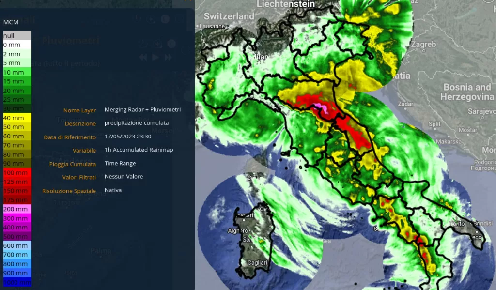
The extreme intensity of rainfall
As we can see from the map of the rainfall that fell during the event (Figure 3), the most affected belt turns out to be Romagna and Marche, where the maximum recorded peaks of precipitation exceeded 200 mm in 48 hours.

The magenta-colored areas indicate cumulative precipitation in excess of 200 millimeters, falling mainly on the mountainous parts of the basins. The image shows that precipitation fell heavily only on the Adriatic side of the two regions, just as it did on May 2 and 3.

Demonstrating the stratiform nature of rainfall, look at the data recorded by the “Casola Valsenio” rain gauge (Figure 4), which clearly shows that the rainfall is not at very high intensity but very persistent, stationing in a prolonged manner over the same basins. The maximum hourly measurements recorded in the affected areas are around 10-20 mm/h. Some intensities higher than these values were recorded in the Marche region, especially on the day of May 16. Persistence in space and time resulted in the consistent floods in the basins.
Consequences: the floods
The event mainly affected the eastern sector of the Emilia-Romagna Region and the Apennine sector of the Marche. Examples of the many basins affected include the Reno and its various tributaries, the Ronco (590 km2), the Savio (670 km2), the Lamone (500 km2), and the Montone (750 km2), the Metauro (1300 km2), the Foglia (700 km2), and the Esino (1100 km2), as well as smaller tributaries and streams. From the hydrometric series and hydrological simulations we see two or three peaks on many streams over the approximately 48-hour duration.

The purple and red river stretches are those where flows were most critical, with high values less frequent according to the available climatology, and tragically resulting in flooding of the same rivers in several cases.
Figure 6 shows the map of rivers that, according to reconnaissance available at the time, have actually flooded or have reached alarm levels (Source: ARPA Emilia-Romagna).

The help from space
As we analyzed earlier for the flood that, once again, hit the Marche Region in September 2022, having the synoptic picture of the affected areas available in emergency time is of crucial help.
Just as they did last May 2, our researchers were activated to map the flooded areas using satellite data.
Flooded areas are shown in light blue, and permanent water bodies in blue, while the part in transparency delimits the coverage of the satellite image.


The flood depth map, which adds a third dimension and thus photographs the real situation, was generated using as input the flooded areas map produced by CIMA Research Foundation and the digital terrain model (DTM) of the Emilia-Romagna Region, with a spatial resolution of 5 meters. Out of a total of about 58 km2 of flooded area, the average flood height was estimated to be 11 cm, while 10 percent of the area, or nearly 6 km2, has flood heights greater than 68 cm. The greatest depths are located in the immediate vicinity of the hydrographic network along the Ronco River east of Forli and the Savio River north of Cesena, while the areas of greatest flood extent are located in the flatter areas, where depths are mainly less than one meter.
The total volume flooded is estimated at about 6 million m3. Figures 10 and 11 show maps of estimated flood depths in the most affected areas and two enlargements for the Forli (Zoom 1) and Cervia (Zoom 2) areas.


These maps, elaborated from the satellite data we have seen above, with the addition of the depth data provide a very detailed snapshot of the severity of the flooding: in the areas of the province of Forlì – Cesena (as well as elsewhere) they allow us to understand where to prioritize interventions and how to calibrate reconstruction and recovery activities, immediate and future, with greater effectiveness and precision.