Predicting a wildfire means interpreting an unstable balance between vegetation, meteorological conditions, and the dryness state of the land. In complex contexts such as Ethiopia, where different bioregions coexist within the same national system, the challenge is not only to estimate fire danger, but to forecast it operationally using tools calibrated to local specificities and capable of supporting operational decision-making.
Within the MedEWSa project, CIMA Research Foundation led a technical cooperation pathway between the Attica Region and the National Parks of Ethiopia, working to strengthen the national forest fire early warning system in close collaboration with Ethiopia Forestry Development (EFD), a national agency with which the Foundation has been collaborating since 2020.
The intervention followed a dual approach: on one hand, the evolution of the RISICO ETHIOPIA fire forecasting system; on the other, the adaptation and implementation of the PROPAGATOR fire spread simulator in national parks.
RISICO Ethiopia: from a continental model to a national-scale system
The work on RISICO ETHIOPIA represented a substantial structural upgrade of the system, aligning it with the RISICO 2023 standards. The evolution involved both the physical-mathematical core of the model and its computational architecture.

A key development was the introduction of a new model for estimating Fine Fuel Moisture Content, a variable that plays a critical role in ignition and early fire propagation. Fine fuel moisture responds rapidly to meteorological conditions and is one of the most sensitive factors in determining ignition probability.
This was complemented by a new module for estimating the Rate of Spread, based on the formulation used in the PROPAGATOR simulator. The integration of this formulation improves the consistency between fire danger prediction and the dynamic simulation of fire front propagation.
At the same time, the Fuel Module was updated using a Machine Learning-based approach at continental scale, integrating drought indicators, vegetation variables, and Digital Elevation Models (DEM). This module was then spatially extended and refined using local datasets, in order to better represent Ethiopian bioregions.
The system was fully restructured and reorganized, shifting from a continental African scale to a national scale, using local bioregional datasets. This transition is essential: wildfire danger cannot be modeled uniformly across territories characterized by high ecological heterogeneity. The use of vegetation classes and the definition of wildfire susceptibility classes (low, medium, high), based on national percentiles (25th and 75th), enabled the development of dynamic and context-specific fuel maps.
The validation of the updated system was carried out over the 2023–2024 period, using 75,961 hotspots detected by the MODIS satellite sensor, which identifies thermal anomalies largely associated with wildfire events.
Model prediction performance was assessed through a statistical analysis based on the ROC (Receiver Operating Characteristic) curve, which evaluates the ability of a system to correctly distinguish between conditions where fires occur and those where they do not. The summary metric, the Area Under the Curve (AUC), ranges from 0 to 1, with higher values indicating better model performance.
Comparing the previous and updated versions of RISICO, the AUC increases from 0.58 to 0.87, indicating a substantial improvement in the system’s ability to discriminate between fire occurrence and non-occurrence conditions. In operational terms, this translates into a reduction of both false alarms and missed detections.

The evolution of RISICO ETHIOPIA directly feeds into the Forest Fire Early Warning Bulletin (FFEWB), the operational bulletin produced by EFD three times per week (Monday, Wednesday, and Friday), strengthening the decision-making component of the national system.
PROPAGATOR: from prediction to scenario simulation
Alongside the enhancement of the early warning system, the project included the adaptation of the PROPAGATOR fire spread simulator to the Ethiopian context.
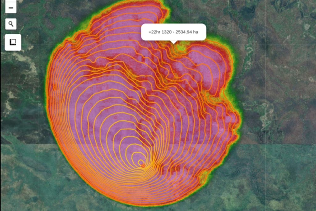
PROPAGATOR is a cellular automata-based simulator designed to model the spatial dynamics of wildfire spread under varying meteorological conditions and fuel states. It uses fine fuel moisture conditions provided by RISICO, ensuring methodological continuity between fire danger forecasting and dynamic scenario simulation.

The code was completely rewritten and reorganized, achieving approximately a 100% increase in computational speed. Computational efficiency is a key aspect: the ability to simulate scenarios within operational timeframes enables timely support for emergency management.
The pilot implementation was carried out in three Ethiopian national parks: Bale Mountains, Simien Mountains, and Gambella National Parks. In these contexts, the simulator allows the exploration of fire spread scenarios under changing meteorological conditions, providing a valuable tool to support planning and wildfire management in the areas considered.
An integrated system to strengthen national capacities
The work developed within this technical cooperation pathway goes beyond the upgrade of individual tools, contributing instead to the construction of an integrated system: fire danger forecasting and modeling, dynamic fuel mapping, validation against observed data, scenario simulation, and the production of operational bulletins.
Collaboration with Ethiopia Forestry Development enabled the adaptation of advanced methodologies to the national context, leveraging local data and strengthening operational capacities.
From the enhancement of RISICO ETHIOPIA to the implementation of PROPAGATOR in national parks, the work carried out within the MedEWSa project represents a step toward more robust wildfire early warning systems, tailored to the ecological characteristics of the territory and fully integrated into decision-making processes.