CIMA Research Foundation resumes its seasonal monitoring of Italy’s snow water resources1 at a crucial stage for the onset of winter accumulation. The 2025–2026 season opened with encouraging signals at the end of November, when favorable thermal and precipitation conditions allowed the first widespread snowfall events across the main mountain ranges. However, the situation changed with the arrival of an intense warm phase in early December, which has already had a significant impact on snow accumulation. While snowfall is currently occurring in Northwestern Italy, at the national scale the snow water equivalent shows a deficit of -52% (data updated to 13 December 2025).
A comprehensive overview of current snow conditions across Italy’s mountain regions is also available on the dedicated webpage.
When cold is not enough
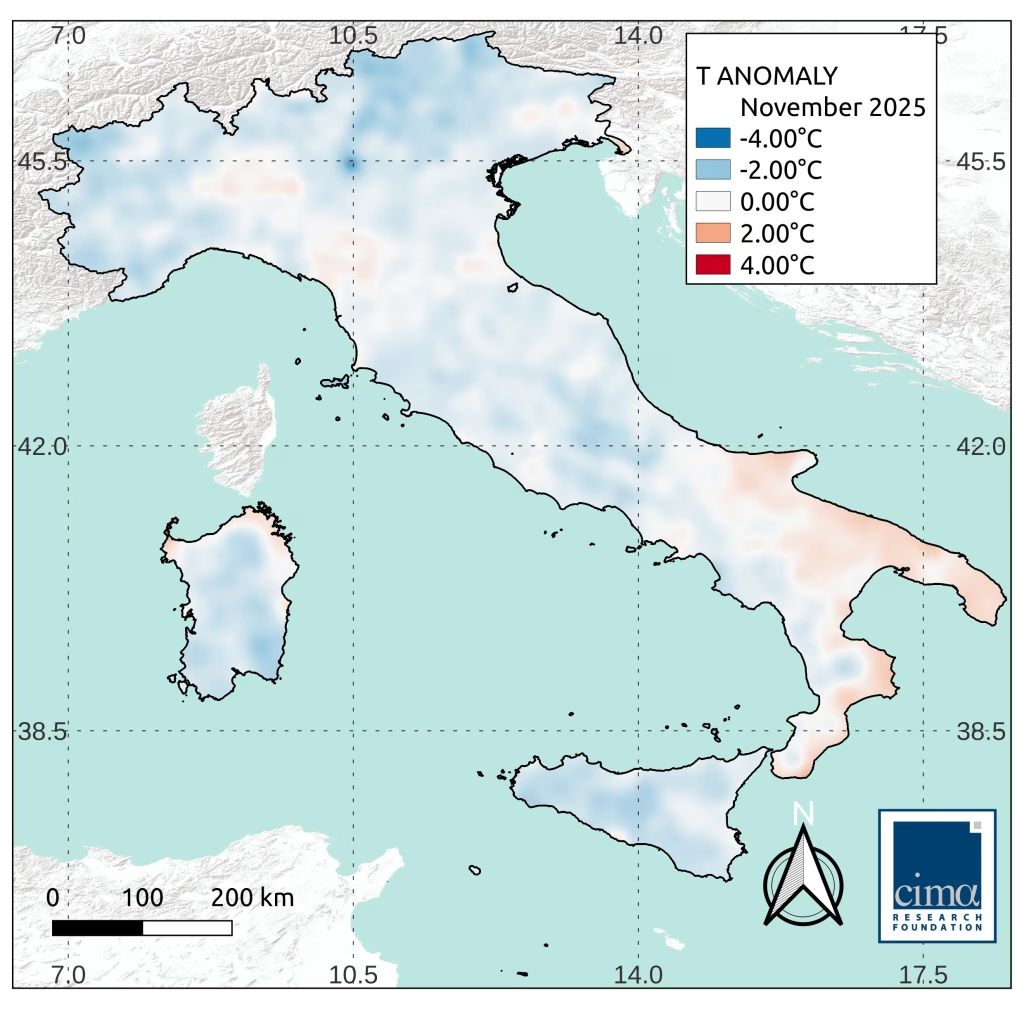
At the core of every snow season lies a well-known mechanism: effective accumulation depends on the coexistence of sub-zero temperatures and sufficient precipitation in the form of snowfall. During November, temperatures were slightly below average across large portions of Italy’s mountain areas, creating favorable conditions for snow, particularly toward the end of the month. This enabled an initial growth of the snowpack, which, however, was not supported by adequate precipitation availability, especially in Northwestern Italy, the core region for the Po basin’s snow water resources.
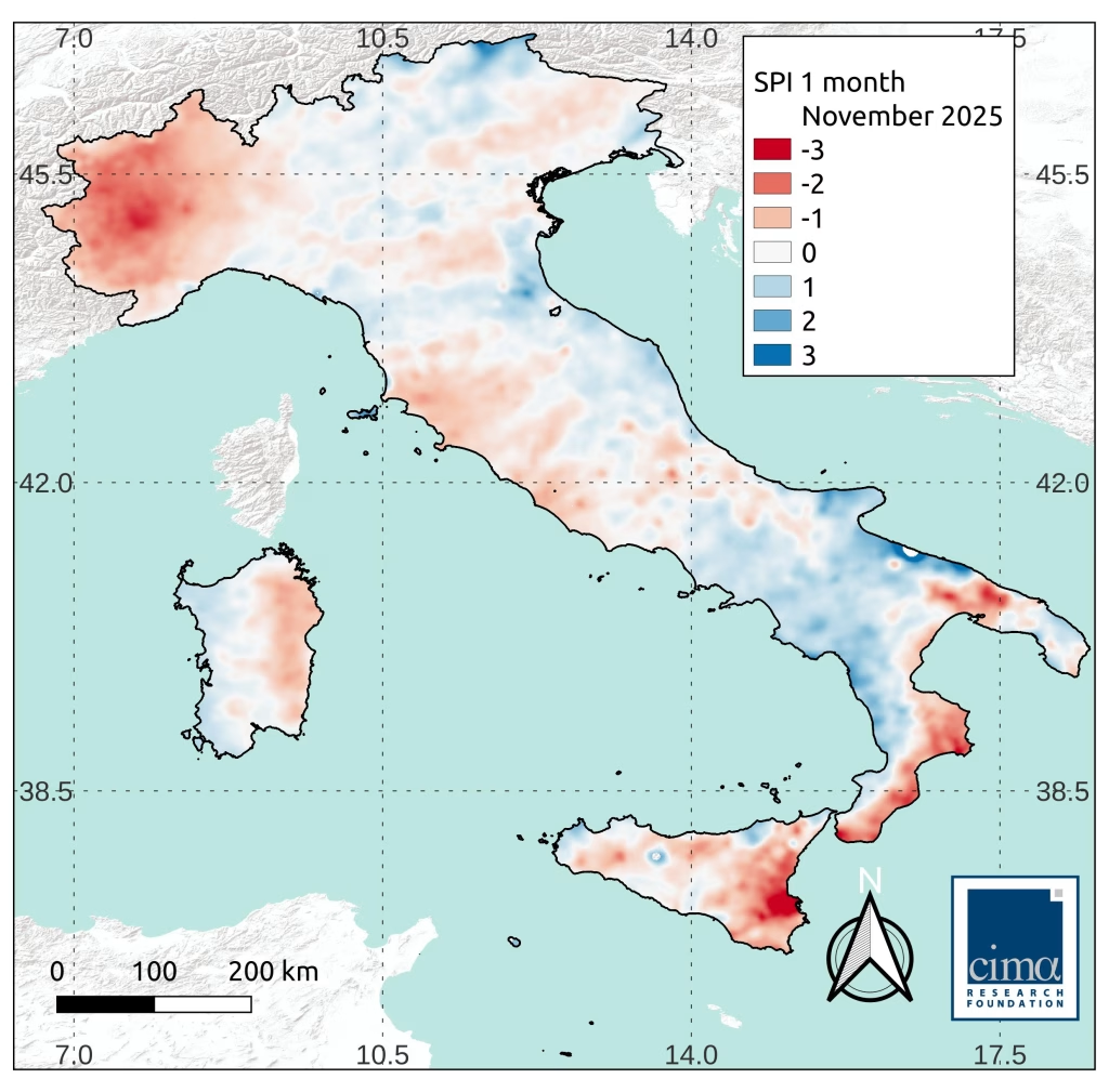
The main limitation of this early seasonal phase was indeed the scarcity of precipitation. Across many parts of the country, particularly in Northwestern Italy and the central Apennines, November recorded precipitation totals well below average, with negative anomalies reaching up to -60% compared to climatological values
This dynamic is clearly visible when examining the evolution of the main Alpine river basins. In the Po basin, the increase observed in November was followed by a phase of substantial stagnation during the first two weeks of December. Such a slowdown at the beginning of the season represents a critical factor, as it introduces a delay that, if not recovered in the following months, may affect the overall winter water balance. As of 13 December, the deficit in the Po basin stood at -48%. New snowfall occurred last Tuesday, particularly in the Cuneo area, where fresh snow accumulations locally exceeded 1 m; in January, it will be possible to assess their contribution and, above all, whether this snow has been able to persist at higher elevations.
Alpine basins and the altitudinal distribution of the deficit
A similar situation is observed in the Adige basin, where the deficit reaches -52%. Conditions are comparable to those observed at the same time last season, which subsequently experienced a significant recovery between January and February. Once again, the evolution of the coming months will be decisive in determining whether snow accumulation can compensate for the initial shortfall.
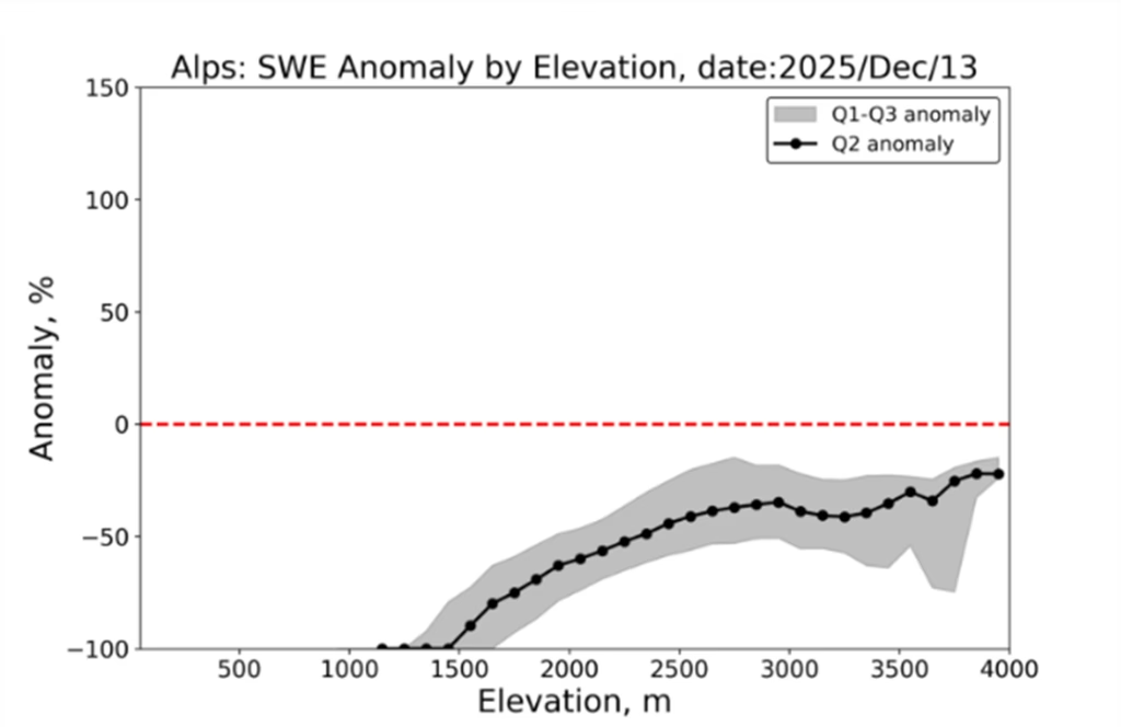
From a spatial perspective, the deficit is not uniformly distributed. In the Alps, the most critical conditions are concentrated at mid to low elevations, below 2000 m, where accumulation is particularly vulnerable to temperature fluctuations. At higher elevations, above 2500 m, conditions are relatively better, although deficits on the order of -25% to -30% persist. This confirms the key role of elevation in determining snowpack stability.
Apennines and ephemeral snow
In the Apennines, variability is even more pronounced. Lower elevations and frequent temperature fluctuations typical of this region make snow accumulation particularly sensitive even to short warm spells. In the Tiber basin, for instance, accumulation was above average at the end of November, but much of the snow subsequently melted, resulting in a current deficit of -58%.
This is an emblematic case of ephemeral snow3, a phenomenon that is becoming increasingly common at mid to low elevations. In an area such as the Apennines, where there is no glacial contribution, understanding how much snow accumulates in the mountains during winter is particularly critical. Precisely to better monitor these dynamics, starting this year we have introduced an integrated indicator for the entire Apennine range, which currently shows an overall deficit of -67%. This figure clearly highlights the fragility of snow accumulation in these areas already during the early stages of the season.
Looking ahead to the coming weeks
Despite the current situation (updated to 13 December 2025), we are still in the early stages of winter, and snowpack evolution remains highly dynamic (as noted, snowfall has just occurred in Northwestern Italy). Seasonal forecasts confirm above-average precipitation in the Northwest for December and below-average precipitation elsewhere. At the same time, temperatures are expected to be markedly above average. The heatwave that characterized the first ten days of December has already illustrated the effects of these conditions, with intense snowmelt especially at mid to low elevations.
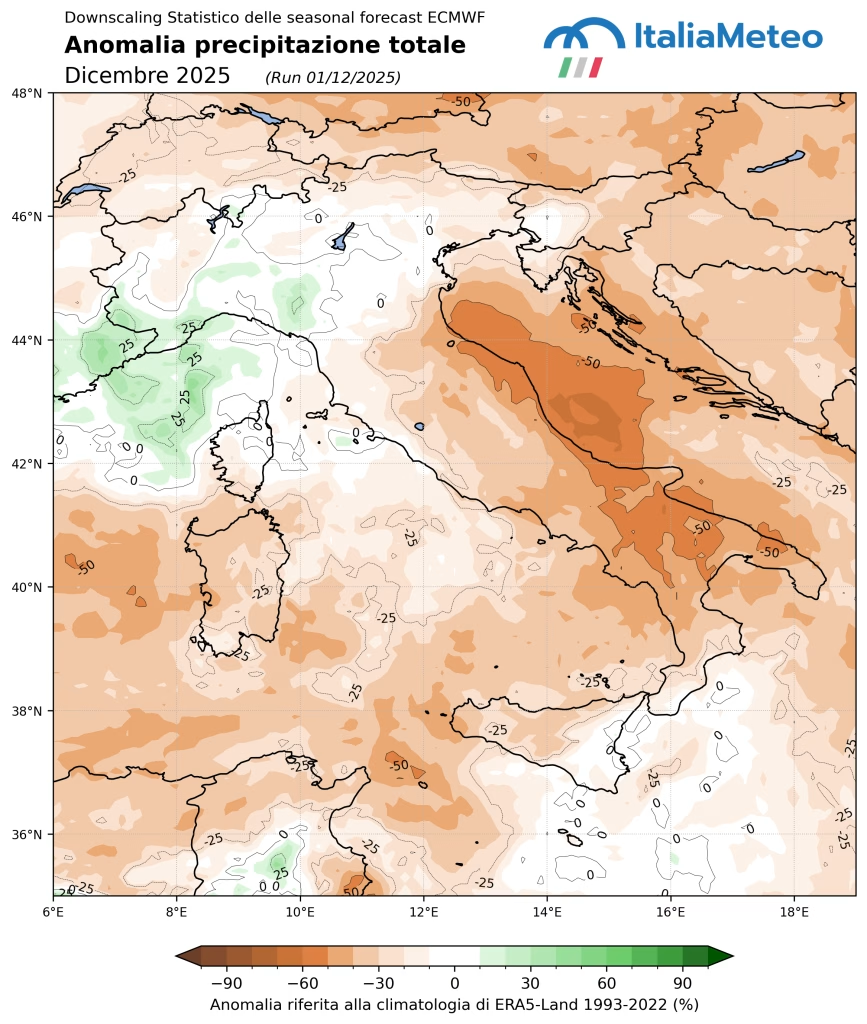
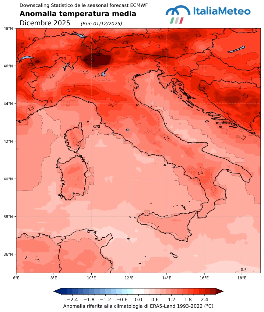
Overall, November provided an initial boost, but the warmth and lack of precipitation during the first part of December have introduced a significant slowdown. The second half of the month will be complex and decisive in determining how the season will ultimately unfold. The next update, scheduled for mid-January, will allow an assessment of how this first phase of the winter season has concluded.
- Snow Water Equivalent (SWE) is a measure representing the amount of water that would result if the snowpack were completely melted. Learn how it is calculated here. ↩︎
- This year, alongside SWE anomalies, percentage precipitation anomalies will also be reported at times. These data must be interpreted with care: SWE anomalies depend not only on precipitation anomalies, but also on temperature conditions. ↩︎
- Ephemeral snow is a phenomenon typical of milder snow-covered areas and occurs when the combination of abundant precipitation and relatively high temperatures prevents snow from consolidating and persisting on the ground. This leads to rapid melting, with significant implications for local resource management. This type of snow, which melts just days or weeks after deposition, has historically been more frequent in the Apennines than in the Alps. However, future climate change scenarios suggest an expansion of these conditions into Alpine regions as well. The rapid alternation between intense but episodic accumulation and prolonged melt periods can generate substantial imbalances in river basins, negatively affecting ecosystem stability and the ability of communities to plan water resource use. We had already discussed this here. ↩︎