Southern Mozambique is experiencing intense rainfall that began in late December and intensified from 10 January onwards, with daily accumulations exceeding 200 mm in several areas. Rainfall reached its highest peaks in recent days and, although a reduction in intensity has been recorded over the last 24 hours, continues to affect the southern part of the country.
This rainfall, together with precipitation in neighbouring countries, has contributed to a significant rise in river water levels along the main river systems in the central–southern part of the country. The Instituto Nacional de Gestão e Redução do Risco de Desastres (INGD) issued a red alert yesterday, valid for the entire country.
According to the various available hydrological models (GLOFAS, FloodPROOFS, FloodHub), water levels have already reached their peak along the Limpopo River, while along the Incomati and Umbeluzi rivers, near the cities of Maputo and Matola, the peak is expected today (17 January), with exceptional values exceeding the 20-year return period. These levels will continue to affect downstream reaches in the coming days, where densely populated areas are located. The Búzi River basin, in Manica and Sofala provinces, experienced rising levels in previous days, and a second peak is forecast in the coming days.
For the weekend, forecasts indicate rainfall of lower intensity compared to previous days, but still significant over the south. This rainfall will fall over completely saturated soils and catchments where river levels remain very high.
In this context, CIMA Research Foundation is providing remote support to colleagues at INGD and other competent institutions within the warning system (INAM, DNGRH), supporting monitoring operations and the analysis of the ongoing event through forecasting and monitoring tools developed under the Ready2Act project, implemented with the support of Italian Cooperation through the Italian Agency for Development Cooperation (AICS). Ready2Act, carried out together with the Italian Civil Protection Department and the NGO WeWorld, invests in preparedness and risk reduction in the areas of Mozambique most exposed to the impacts of climate change.
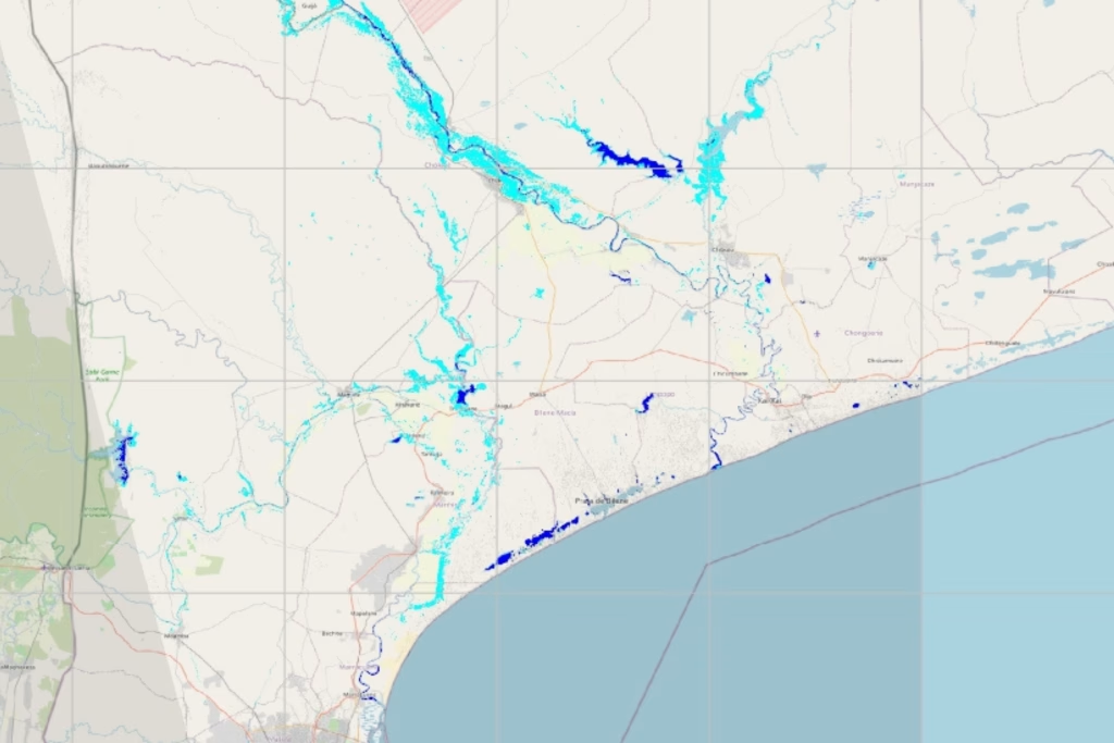
Support includes the processing of Copernicus satellite data (Sentinel 1 and 2) by CIMA Research Foundation technicians on the WASDI platform, which confirms widespread flooding in the southern region, particularly near the mouths of the Limpopo and Incomati rivers. Satellite monitoring products and analyses are shared with Mozambican colleagues also through the Dewetra platform, facilitating operational coordination during this delicate emergency phase.

Technical support provided during this emergency is further strengthened through activation by the Emergency Response Coordination Centre (ERCC) via the Aristotle mechanism, providing enhanced forecast detail for the affected areas.
Responding to events such as this requires timely and continuous monitoring, in which coordination between institutions and the scientific community becomes essential to support informed decision-making and contribute to risk reduction.
Update – 19 January 2026
Over the next 72 hours, a gradual improvement in rainfall conditions is expected, particularly in Maputo Province. However, variability among the different forecasting models persists: across large portions of Gaza and Inhambane provinces, rainfall accumulations exceeding 50 mm in 72 hours are still forecast, with local maxima potentially above 150 mm. These amounts could lead to further hydrological impacts and flooding events, especially in the lower Limpopo basin (including the Changane River) and in smaller coastal catchments. Intense rainfall in the upper Limpopo basin could also slow down the runoff phase and the decline of water levels in downstream areas, prolonging impacts in zones already affected by flooding.

The most recent satellite observations (Sentinel 1–2, Copernicus) confirm ongoing flooding in the downstream reaches of the Buzi, Limpopo and Incomati rivers.


The situation remains highly critical because the forecast rainfall will affect basins already characterised by saturated soils and high water levels, making a worsening of conditions possible even in the event of new, short-duration rainfall events.

The area of greatest concern remains the downstream portion of the Limpopo basin, particularly in Gaza Province, which has already been affected by extensive flooding. Forecast intense rainfall in the upper basin could further slow the recession of water levels. Critical conditions are also possible in coastal catchments within Inhambane Province. In addition, the persistence of rainfall may complicate ongoing civil protection operations. In this context, the operational management of water resources also plays an important role: reservoir releases currently underway may contribute to further increasing downstream discharges, worsening flood conditions.


Gaza Province. Fonte: Mercy Air – Mozambique Flood Survey (18-01-2026)
Update – 22 January 2026
Over the last 48 hours, no new rainfall has been observed in southern Mozambique. Despite this local improvement in rainfall conditions, the hydrological evolution remains critical in the most vulnerable areas, with river levels still rising in the downstream reaches of the Limpopo basin.

For the next 72 hours, forecasts indicate overall weak precipitation over the areas recently affected by flooding, with accumulations generally below 5 mm/72 hours. Persistent rainfall is however expected over the headwater catchments of the Limpopo (in Botswana and Zimbabwe, along the Shashe and Motlouse rivers) and over the upper Save basin, with cumulative rainfall below 50 mm/72 hours. Under already elevated river stage conditions, these inputs may contribute to slowing the return of water levels towards normal conditions.

The area of greatest concern remains Gaza Province (with 115,000 people potentially at risk), particularly the downstream portion of the Limpopo basin (including the Xai-Xai area), where rainfall over the past few days is driving a further increase in water levels along the main stem of the Limpopo River and along the Changane River. FloodHub (Google) simulations also indicate that the Limpopo River near Xai-Xai may reach its peak in the coming days, with levels well above the seasonal average.

In addition, the possibility of a dam breach in South Africa has been reported, in the upper parts of the Incomati basin. At present, considering the reservoir size and its distance from the border, the expected impacts in Mozambique should be limited.
Update – 29 January 2026
In recent days, no significant rainfall has been observed in southern Mozambique. River stages in the main southern basins (Buzi, Limpopo, Incomati and Umbelezi), which in previous days had reached values above the threshold associated with a 1-in-20-year return period, are now slowly decreasing, while still remaining at high levels, particularly along the Limpopo and Incomati rivers, north of Maputo.

The most recent satellite observations (Sentinel-1 acquisitions on 28 January, Copernicus) confirm that severe flooding is still occurring in the downstream portions of the Limpopo and Incomati rivers, with signs of slight improvement especially along the Incomati.
For the next 72 hours, multi-model forecasts indicate a general improvement in meteorological conditions: no significant rainfall is expected over the areas most affected by the recent flooding in the lower Limpopo region, nor over the Save and Buzi basins. According to some forecast scenarios, however, the upper Limpopo basin in South Africa may record locally accumulated rainfall around 40 mm over 72 hours.

Attention is also shifting towards the northern provinces of the country, where rainfall is currently ongoing (a tropical depression has developed in the Mozambique Channel and is moving eastwards towards Madagascar), and where models foresee a general increase in water levels in the main river courses, with significant peaks especially along the Messalo and Montepuez rivers. A possible rapid activation of the minor coastal river network is also expected between the weekend and the beginning of next week, with peaks that may exceed a 1-in-30-year return period.

Finally, the models (FloodHub) indicate a high probability of flash flood events in the Nacala area over the next 24–48 hours.
The main areas of concern remain the lower Limpopo basin in Gaza Province (including Xai-Xai) and the lower Incomati basin in Maputo Province, where extensive inundations are confirmed by satellite imagery and water levels, although slowly receding, remain widely above normal.

Update – 4 February 2026
Hydrological conditions in southern Mozambique are showing signs of gradual improvement. From a meteorological perspective, no significant rainfall has been recorded in recent days over the areas most affected in the south of the country and across the Limpopo and Incomati catchments. From a hydrological standpoint, river stages in the main basins of the Buzi, Limpopo, Incomati and Umbeluzi rivers, which in previous days had reached values above the threshold associated with a 1-in-20-year return period, are now slowly decreasing.
In addition, the most recent satellite observations (3 February, Sentinel-1, Copernicus) confirm that flood extent in the downstream portions of the two rivers is shrinking, indicating a progressive improvement of the situation.
Meanwhile, within the framework of the European Union Civil Protection Mechanism activated for this emergency, a CIMA Research Foundation expert in Flood Risk Management is also on the ground, as part of the European contribution supporting risk management activities.

For the next 72 hours, multi-model forecasts show good agreement in indicating the absence of significant rainfall over the areas most affected by the recent flooding in the lower Limpopo and Incomati regions, as well as in the upstream portions of the two basins.
Moderate rainfall remains possible over the northern provinces (Niassa and Cabo Delgado), particularly along the border with Tanzania and over coastal areas, with forecast accumulations around 50 mm over the next 72 hours across the Rovuma, Messalo and Montepuez catchments. These precipitation inputs may result in a slight increase in water levels in the river courses of the northern region.

The main areas of concern remain the lower Limpopo basin in Gaza Province (including the city of Xai-Xai) and the lower Incomati basin in Maputo Province, where above-normal water levels were recorded in recent days and are now slowly receding. Although in recession, extensive inundations persist, as confirmed by the latest satellite imagery.
