CIMA Research Foundation participates in several projects, particularly those funded by ESA, dedicated to the development of a “Digital Twin” for the hydrological cycle, that is, one that can represent the water cycle at a large scale. With Simone Gabellani, head of Hydrology and Hydraulics Department, we delve into the topic of Digital Twins in this field, with a focus on the role of satellites
A virtual copy of our world, or at least some aspects of it: of a river basin, for example, on which to simulate different scenarios, design interventions, and analyze data. This is the principle behind Digital Twins, technologies that today are increasingly attracting the attention of various fields in the scientific world for their potential applications, ranging from urban management and planning to medicine. Up to hydrology: in fact, it was precisely to Digital Twins that the DTE Hydrology Evolution project was dedicated, with CIMA Research Foundation as one of the partners and which recently concluded. And it is also with the growing importance of these tools in mind that CIMA Research Foundation developed its strategic program Technological Development in the Digital-Twin Era.
How is it working in this field? What are the current difficulties, what are the future prospects? We discuss this with Simone Gabellani, head of the Hydrology and Hydraulics Department of CIMA Research Foundation.
The satellite look
“As CIMA Research Foundation, we have participated or are participating in several projects, funded by ESA, working in the field of Digital Twin: these are DTE Hydrology, and its ideal continuations DTE Hydrology Evolution and 4DMED Hydrology, united by the goal of exploiting more and more and better satellite data to reconstruct the hydrological processes and impacts of their extremes on the society” Dr Gabellani says.
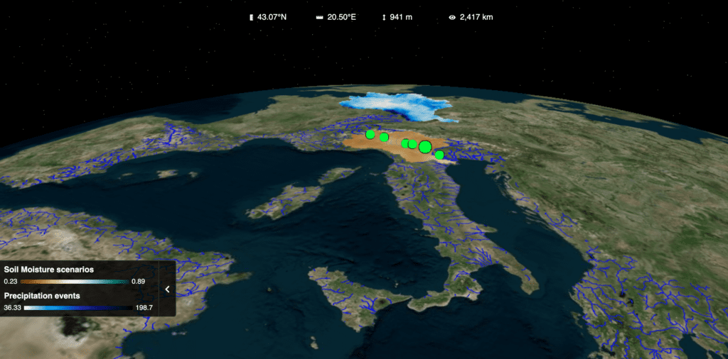
In fact, as we had already explained, satellites can provide fundamental support to fill the gaps of in situ sensors, which cannot always reach every place on the planet (think of the most remote or impervious areas) and, in any case, provide punctual and space-limited data. Consider, for example, data regarding precipitation, one of the variables that most influence hydrological phenomena. In Italy, ground-based instrumentation can be considered detailed, because it counts on about 4,000 rain gauges and 23 radars; however, it is not always sufficient to capture the real dynamics of the process. This is because rainfall has a high variability in space and time: “photographing” the data at a certain point does not mean, therefore, being sure to report it correctly the area surrounding it.
In this sense, having a coherent vision of space like the one offered by satellites becomes crucial even for the most in situ sensors-rich countries. Hence the desire to explore the potential of satellites. The ultimate goal of ESA’s strand of projects is ambitious: to develop a Digital Twin Earth (DTE) that, by integrating data from different sources, allows the dynamics of different geophysical phenomena on Earth to be reproduced.
Big Data, ICT and Artificial Intelligence
Scientific research has highlighted the importance of being able to merge and integrate data from different sources, to have as complete a picture as possible of the phenomenon being studied, even if it is very complex, large-scale or, as in the case of the DTE, if it brings together many different phenomena and dynamics. “In the case of the hydrological cycle, for example, we can say that with ground-based sensors we have precise information if a point but difficult then to “spatialize,” to report over a larger area; vice versa, satellite data provide more uncertain estimates, but they are available on much larger areas,” Dr Gabellani explains.
Yet, there is another question: how to represent – and use – such data? Traditionally used physical models reproduce the various components of a phenomenon, but are based on simplified equations that lead to simplification. This is where the Digital Twin comes in, by taking advantage of new AI algorithms that reduce uncertainty and correct process simulations, thanks to the huge amount of data currently available.
“That of Digital Twin Earth, although it does not have an unambiguous and shared definition, represents a paradigm born out of the needs of the scientific community itself,” the researcher says. “The idea is to enhance knowledge, developments and, above all, modeling of geophysical phenomena (understood as all the interaction processes of the Earth’s dynamics) by leveraging ICT and artificial intelligence technologies to take advantage of the amount of data, conventional and otherwise, that we now have available.”
“This would enable improving the representation of several hydrological processes: for example, we are observing that some algorithms for interpolating ground-based data are able to represent well the spatial distribution of variables such as evapotranspiration (the amount of water that transpires from plants or evaporates from the ground), in a way that classical modeling and techniques cannot. In fact, AI allows us not only to work with physical equations but also to extract the likely dynamics of processes based on a model “training” on past data.”
Anthropic activities and other challenges
Where are we, then, in the development of these tools? Of course, we are talking about technologies that are still in the making – but whose early results look promising. The recently concluded DTE Hydrology Evolution project, for example, has led to the development of a first prototype of a large-scale hydrological Digital Twin, covering the entire Mediterranean basin. It is indeed only a prototype, but one that already allows several operations to explore data and modeling results thanks to the ADAMPlatform, which was developed ad hoc.
In general, scientific interest in the field of Digital Twin Earth is currently very high: the aforementioned ESA projects, in which CIMA Research Foundation also participates, are in fact a contribution to the European Commission’s Destination Earth (DestinE) initiative, which aims to develop a Digital Twin at a global scale to replicate natural phenomena and interaction with human activities. The latter aspect is far from trivial: in the age of the Anthropocene, in fact, many natural phenomena-not least the hydrological cycle-are being influenced by our activities, which can therefore no longer be disregarded.
“Taking anthropogenic activities into account represents one of the main challenges in this type of study. In the case of the water cycle and in the context of ESA projects, for example, we are trying to evaluate, through satellites, data concerning agricultural irrigation,” Dr Gabellani says. “Another key research line today concerns the estimation of river flows from satellites – it is a challenge, because it is very difficult, today, to understand from satellite data how much water is flowing in a river at any given time. Within DTE Hydrology, for example, some project partners had focused on this very objective, getting good results for the Po River basin, which we had worked on for other variables, including precipitation, snow depths and evapotranspiration.”